Meshtastic 2.8 New Features: AI, Beacons, NFC Tag Sharing, and More
Published by Vivian van Zyl in Meshtastic the 08/20/2026 at 11:37 pm

Meshtastic 2.8 is a big release for off-grid LoRa mesh communication. This is not meant to be a complete changelog, but after spending some time in the Android app, these are the features that stand out most: cleaner connections, local mesh discovery, privacy changes for public channels, built-in ATAK support, diagnostics, waypoints, GPX export, and quite a few interesting extras.
Some of these are immediately useful. Others, especially the new AI options and mesh beacons, look promising but need more time in the field. Either way, version 2.8 adds a lot of practical capability to Meshtastic.
Table of Contents
- A Cleaner Android App Connection Screen
- Find Nearby Networks With Local Mesh Discovery
- System AI Controls With Gemini
- Public Channel Location Sharing Is Now Less Precise
- Mesh Beacons: A New Way to Advertise Mesh Information
- ATAK Integration Without the Old Plugin
- Built-In Device Purchase Links
- Share Contacts Using NFC Tags
- Signal Quality and Noise Floor Diagnostics
- Waypoints, Geofences, and Node Density by Hop
- Export GPS Tracks as GPX Files
- Meshtastic 2.8 Is a Serious Step Forward
A Cleaner Android App Connection Screen
The first change is visible before connecting to a node. Instead of showing a long historical list of devices, the connection screen now focuses on nodes that are actually available.
You can still choose the connection method, including network, USB, or Bluetooth. When using Bluetooth, the app displays the Bluetooth RSSI as well. That is handy because it gives a quick indication of how strong the phone-to-node connection is before connecting.
Once connected, the familiar node interface is there, but a couple of small additions are worth noting:
- Status messages can be shown on a node.
- Security badges identify messages using the newer security approach.
- Node names appear more restricted in length, with longer names being cut off compared with earlier versions.
To add a status message, open the settings cog, choose All Settings, go into Module Configuration, and select Status Message. It is a simple place to add a short piece of information about your node, location, or current setup.
Find Nearby Networks With Local Mesh Discovery
Local Mesh Discovery is one of the more interesting additions in Meshtastic 2.8. It gives you a way to scan for other meshes in your area instead of simply waiting to happen across them.
From Settings, open Local Mesh Discovery. You can choose which modem presets to scan for, including LongFast, LongTurbo, or all available options. Set a scan duration, start the scan, and optionally keep the screen awake while it runs.
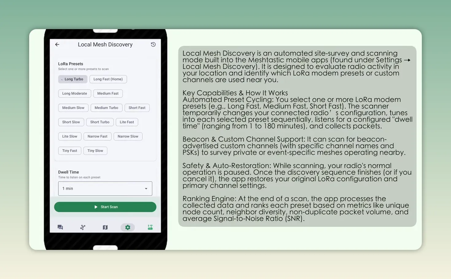
Completed scans are saved in a discovery history. Opening one shows the scan details and the network that was found. This should make it much easier to learn what mesh activity exists locally and which modem presets people are using.
System AI Controls With Gemini
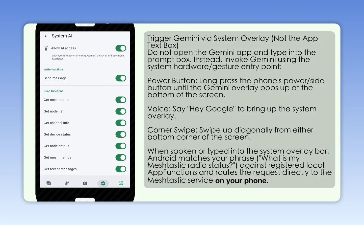
AI features are appearing everywhere, and Meshtastic 2.8 has joined in with a new System AI area. The app can use a local AI option such as Gemini and grant it access to selected Meshtastic actions.
The available controls include actions such as:
- Sending a message
- Retrieving node status
- Getting a list of nodes
Each action can be enabled or disabled individually, which is a good approach. The feature looks very cool, although it is still something to test carefully before relying on it. It was not working in this initial setup, but it is definitely one to keep an eye on as the feature matures.
Public Channel Location Sharing Is Now Less Precise
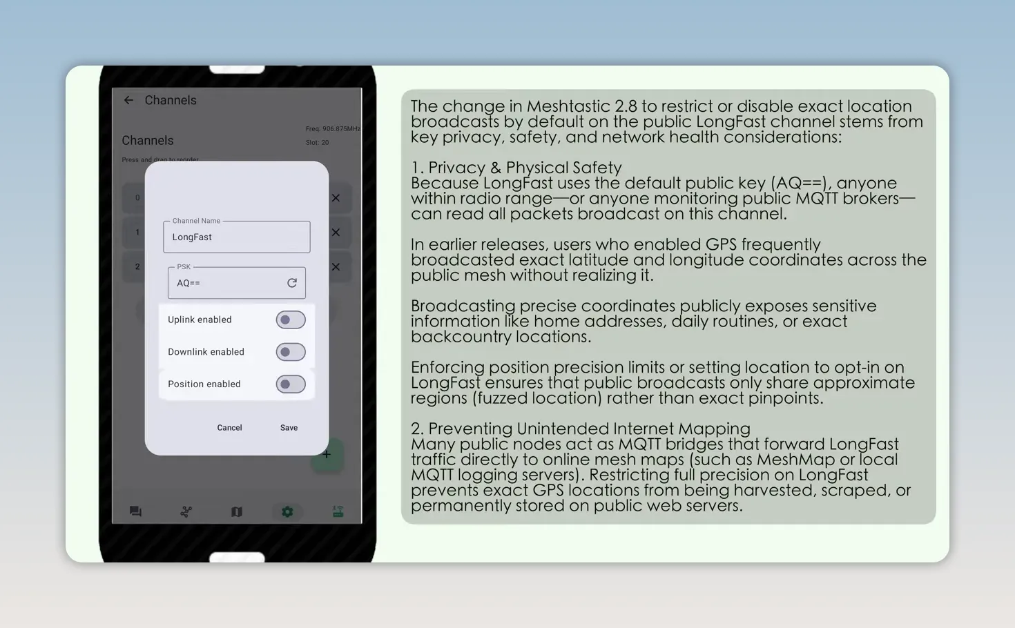
One of the most important changes in 2.8 is the new position-sharing behavior on public channels such as LongFast. Precise location is no longer allowed there.
If you attempt to enable precise position sharing on a public channel, Meshtastic rejects the change and reports that precise position is not allowed on a public channel. Even a location setting around 597 feet was still rejected in this test. At roughly 1.8 miles of precision, the app accepted the setting.
This is fundamentally a privacy and security improvement. A public channel can be useful for general awareness, but it should not automatically reveal somebody's exact location.
The practical way to handle this is straightforward:
- Keep public-channel location sharing coarse, or turn it off.
- Use a private channel shared only with your own nodes or trusted group.
- Enable precise location sharing on that private channel when it is genuinely needed.
That way, your other nodes on the same private channel can receive precise coordinates without putting them onto the public LongFast channel. If you need a refresher on the difference between public and private channels, this guide to public versus private channel keys is useful background.
Mesh Beacons: A New Way to Advertise Mesh Information
The new Mesh Beacon module is another feature that looks like it could become very useful. It includes options to listen for beacons and to share beacon location.
In the Mesh Beacon configuration, you can set:
- Whether the node listens for beacons
- Whether it shares a beacon location
- The beacon transmission interval
- Channel information, including a channel name and region
- Broadcast targets, such as sending the beacon over LongFast
The idea is that nodes can advertise useful mesh information and help others discover a local network. There is still plenty to explore here, but the configuration options suggest this could become a very neat tool for building and finding meshes.
ATAK Integration Without the Old Plugin
The ATAK work in Meshtastic 2.8 is probably one of the biggest changes in the release. ATAK has been substantially overhauled, and Meshtastic now includes an ATAK server directly in the app.
To use it, enable the ATAK server. It runs on port 8089. Then export the ZIP package and import it into ATAK. This replaces the older ATAK plugin workflow. Turn on the server, export the package, import it into ATAK, and set your team and role in Meshtastic.
You can select a team and a role, such as an ATAK tracker. Once the ATAK server is running and ATAK is connected successfully, your Meshtastic node position can appear on the ATAK map, even when the phone itself is not connected to the internet.
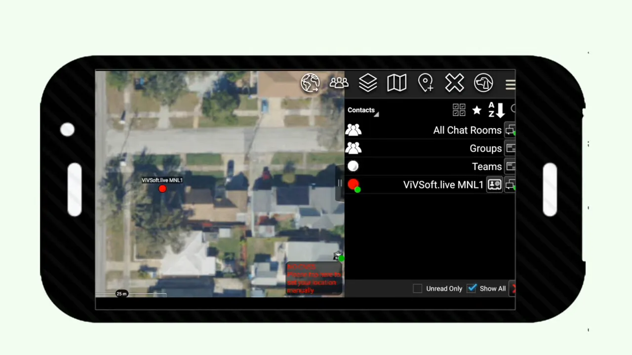
There is also ATAK chat, including chat rooms and direct conversations. The important bit is that messages and node discovery can happen through Meshtastic LoRa using the included ATAK server. No separate ATAK plugin is needed anymore.
ATAK itself has a huge amount of capability beyond Meshtastic, including team organization, tracking, and route and map tools. Meshtastic 2.8 makes it far more approachable to connect that capability to an off-grid mesh.
Built-In Device Purchase Links
Meshtastic 2.8 now includes Device Links in the app. There are links to hardware that can be purchased, and individual nodes can show an I want one option with purchase links for that particular device.
It is clearly intended to make hardware discovery easier from within the app. If you are looking for a compact GNSS-capable development board, the Heltec T096 tracker board is one of the hardware options referenced for this kind of Meshtastic setup.
Share Contacts Using NFC Tags
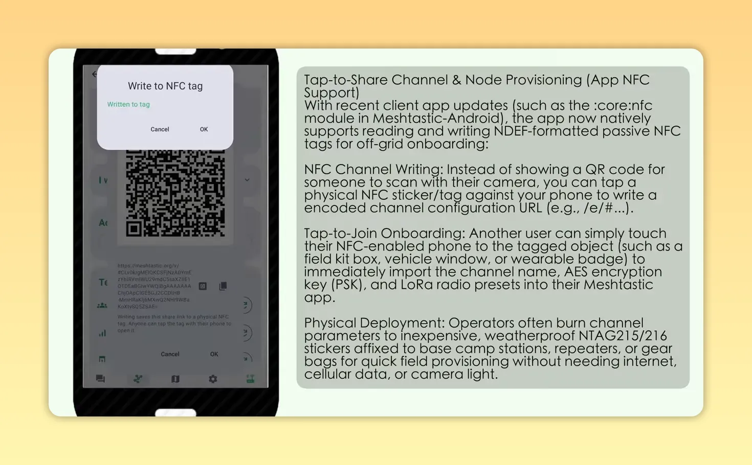
Meshtastic has long supported sharing a contact through a QR code or a link. Version 2.8 adds NFC contact sharing and writing, which is a really nice physical-world addition.
From the contact-sharing screen, use the NFC writer button and hold a compatible NFC tag against the back of the phone. Meshtastic writes the contact information to the tag. The tag can then be placed somewhere useful, such as at an event, a meeting point, or a community mesh noticeboard.
Anyone with the appropriate phone can tap the tag and receive a prompt to import the contact. It is a quick way to make a node or contact available without typing keys, scanning a printed QR code, or sending a link manually.
Signal Quality and Noise Floor Diagnostics
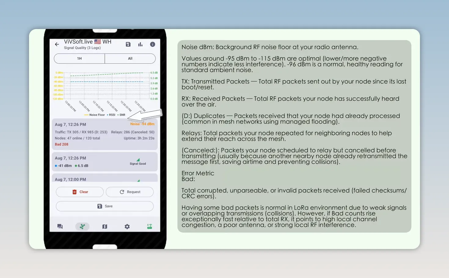
The new signal-quality information is one of my favorite additions. Open a node, select Signal Quality, and request the data. Meshtastic now shows a useful diagnostics card with much more than a simple connection indicator.
The card includes information such as:
- Noise floor
- Transmitted and received packet counts
- Relay counts
- Canceled packets
- Packets that could not be decoded
- Node uptime
The noise floor is particularly valuable. It gives you a better sense of the radio environment around a node, including whether local noise may be affecting performance. Combined with the packet counters, this can help troubleshoot antenna problems, interference, and connection issues much more effectively.
Waypoints, Geofences, and Node Density by Hop
Waypoints are another very useful addition. On the map, long-press a location to create a new waypoint. Give it a name and description, lock it if needed, and choose when it should expire.
You can also add a geofence to the waypoint. Set a circular radius, such as two miles, and choose whether Meshtastic should notify you when somebody enters or exits that area. You can also define an area by selecting points on the map instead of using a simple circle.
Once saved, the map displays the geofence. Notifications appear in the app, although the Bluetooth app needs to be connected for those notifications to come through.
The node list also has a useful Nodes per Hop view. It shows how many nodes have been seen at each hop count over a selected time period. If most of your nodes appear three, four, or five hops away, while very few are at zero or one hop, it quickly tells you that you are a little removed from the local activity.
Export GPS Tracks as GPX Files
The final feature worth calling out is GPX export. Open a node with recorded position information, go to its location history, and use the download arrow to export the track as a GPX file.
A GPX file can be imported into a dedicated GPX viewer for more detailed examination than the in-app map provides. This is useful for reviewing a tracker route, preserving a trip, or using the data with external mapping tools.
For the step-by-step export workflow, see how to export Meshtastic tracks as GPX files in Meshtastic 2.8.
Meshtastic 2.8 Is a Serious Step Forward
There is a lot in Meshtastic 2.8. The new privacy treatment for public-channel location sharing is sensible, the diagnostics give us better tools for solving real radio problems, and local discovery, beacons, NFC sharing, and GPX export all add useful practical features.
The built-in ATAK server is especially exciting for anyone building an off-grid tracking or team communication setup. Add in the early System AI controls, and it is clear that Meshtastic is growing well beyond basic text messaging while keeping the mesh at the center of it all.
Frequently Asked Questions
Can Meshtastic 2.8 share precise GPS coordinates on LongFast?
No. Meshtastic 2.8 blocks precise position sharing on public channels such as LongFast and requires a much coarser location setting.
How can I share precise location in Meshtastic 2.8?
Use a private channel shared with trusted nodes, then enable precise location sharing on that private channel.
Does Meshtastic 2.8 still need an ATAK plugin?
No. Meshtastic 2.8 includes an ATAK server. Enable it, export the ZIP package, import that package into ATAK, and connect through the built-in server.
What does the Meshtastic Signal Quality screen show?
It shows diagnostics including noise floor, transmit and receive counts, relays, canceled packets, undecodable packets, and node uptime.
Can Meshtastic 2.8 export location history?
Yes. A node's GPS position history can be exported as a GPX file for use in external GPX mapping applications.